Trip 1942 - Rae Lakes
Description:
In September 1942 Frank Moore, Joe Momyer and H. B. Richardson took a trip across Kearsarge and Glen Passes. Many mountain vista pictures were taken from the passes, and around Bullfrog Lake between the passes, and in the Ray Lakes and Dragon Lakes areas north of Glen Pass.
Maps:
The Mt Whitney 1937 30 minute US Topo map provides an excellent overview, and was probably carried by the party.
On 7.5 minute US Topo maps: The trip starts on the Kearsarge Peak map. Most of the trip is on the Mount Clarence King map. Photo vistas extend to the Mt. Brewer map to the south and the Mt. Pinchot map to the north.
Photos:
|
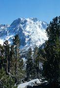
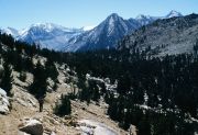
University Peak, seen looking south from the Kearsarge Pass trail. (image: 1942 012) |
|
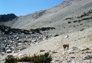
Climbing Kearsarge Pass. (image: 1942 013) |
|
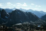
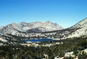
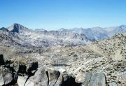
View southwest from Kearsarge Pass. Kearsarge Pinnacles. Mount Brewer, North Guard and Mount Farquhar in distance. Kearsarge Lakes left and Bullfrog Lake right. (image: 1942 014) |
|
Kearsarge Pinnacles, seen southeast across Kearsarge Lakes. (image: 1942 016) |
|
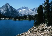
Mount Bago, seen west across Bullfrog Lake. (image: 1942 017) |
|
East Vidette left and Deerhorn Mountain center, seen south across Bullfrog Lake. (image: 1942 018) |
|
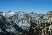
Mount Brewer to the left, North Guard in the center and Mount Farquhar to the right. Seen from Bullfrog Lake area. (image: 1942 019) |
|
Center Basin and Center Peak with Mount Keith behind, seen southeast up Bubbs Creek from Bullfrog Lake area. (image: 1942 020) |
|
East Vidette from Glen Pass trail above Charlotte Lake. Center Peak in front of Mount Keith to left. Mount Stanford in front of East Spur to right, and Deerhorn Mountain over Mount Bago shoulder. (image: 1942 021) |
|
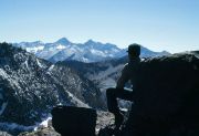
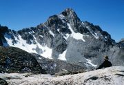
Mount Clarence King, with the long ridge running to the east, seen looking north from atop Glen Pass. (image: 1942 022) |
|
Mount Brewer, seen southwest from atop Glen Pass. (image: 1942 023) |
|
Black Mountain and Sierra crest above Dragon Lake. (image: 1942 024) |
|
Mount Rixford, seen from below Glen Pass. (image: 1942 026) |
|
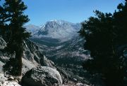
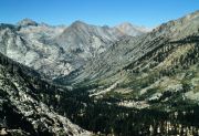
South Fork of Woods Creek. Baxter Creek coming in from the right. Seen looking north from Dollar Lake or Arrowhead Lake area. (image: 1942 027) |
|
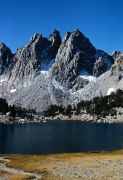
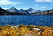
Dragon Lake, across to Fin Dome. Mount Cotter, with double summit, and Mount Clarence King to right of Fin. (image: 1942 028) |
|
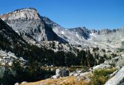
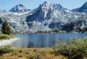
Painted Lady above Rae Lakes. Mount Rixford directly behind, and east peak of Mount Rixford to left. Glen Pass to right. (image: 1942 029) |
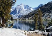
|
Painted Lady and Glen Pass across Rae Lakes. (image: 1942 030) |