Trip 1948 - Forester Pass and Milestone Creek
Description:
In August 1948 Frank Moore and his wife took a trip to the Milestone Creek region of the headwaters of the north fork of the Kern River.
Starting at Onion Valley west of Independence, California, they rented a single pack-mule, and crossed Kearsarge Pass and proceeded up Bubbs Creek to Forester Pass. Descending the Tyndall desolation, they crossed over to the Kern River, probably just north of Milestone Creek. Traveling up the Kern, they then crossed back to the Tyndall drainage at Lake South America, and then returned via Forester Pass.
One photo had the most interesting original caption - "from Milestone Plane wreck Whitney". The exact location from which the photo was taken could not be determined, probably from the Thunder Mountain drainage, but possibly Milestone Creek. An internet search for details of a crash were unproductive - there were many during the war. Frank Moore had participated in searches for downed planes closer to his home in the San Bernardino mountains.
Maps:
The trip starts and ends on the Mt. Pinchot 15' map, but the bulk of the trip can be followed on the Mount Whitney 15'.
Photos:
|
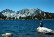
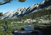
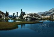
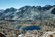
West Vidette and West Spur, seen across Bullfrog Lake, with Deerhorn Mountain (two sharp peaks) to left. (image: 1948 387) |
|
East Vidette (left) and Deerhorn Mountain, seen south from Bullfrog Lake area. (image: 1948 389) |
|
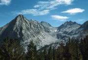
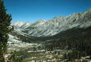
Center Peak, up Bubbs Creek. (image: 1948 390) |
|
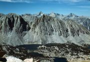
Bubbs Canyon and Center Peak, seen south from below Bullfrog Lake. (image: 1948 391) |
|
Kearsarge Pinnacles above Bubbs Creek. (image: 1948 392) |
|
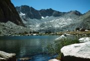
East Spur and East Vidette, seen west from Golden Bear Lake in Center Basin. (image: 1948 395) |
|
Mount Stanford with Gregorys Monument hidden behind, from Bubbs Creek headwaters on Forester Pass trail near Center Peak. (image: 1948 396) |
|
Mount Stanford, seen from Forester Pass trail. (image: 1948 397) |
|
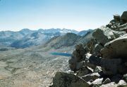
Kaweah Peaks, from Forester Pass. (image: 1948 402) |
|
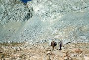
Forester Pass cliff. (image: 1948 403) |
|
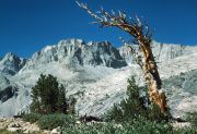
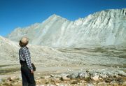
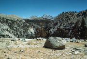
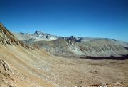
Mount Tyndall, seen across Tyndall desolation on south side of Forester Pass. (image: 1948 404) |
|
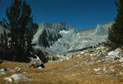
Milestone Mountain. (image: 1948 405) |
|
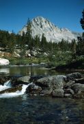
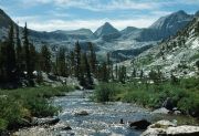
Upper Kern. (image: 1948 406) |
|
Mount Russell and Mount Whitney, see from 'Milestone plane wreck' in Thunder Mountain drainage near upper Kern River. (image: 1948 407) |
|
Table Mountain. (image: 1948 410) |
|
Table Mountain, seen from trail between Milestone Creek and Lake South America. (image: 1948 411) |
|
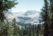
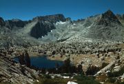
Centennial Peak, Milestone Mountain and Midway Mountain, seen SW from near Lake South America as trail drops into upper Kern River basin. (image: 1948 412) |
|
Mount Russell, Mount Morgenson, Mount Whitney, Mount Hale, seen SE from the top of the trail from Lake South America down to Tyndall Creek. (image: 1948 413) |
|
Junction Peak, from Bubbs Creek headwaters on Forester Pass trail near Center Peak. (image: 1948 415) |
|
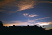
Sunset over Mount Bago, seen from Bullfrog Lake. (image: 1948 418) |
|
Mount Brewer behind Kearsarge Pinnacles. (image: 1948 419) |